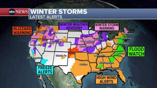
(NEW YORK) — Two major storms are moving across the United States from west to east with blizzard conditions, flooding, tornadoes, strong winds and heavy snow.
There are currently 13 states on flood watch from Georgia to Maine as the storm is expected to reach the East Coast with severe weather for the Carolinas, Florida and Georgia with tornadoes and flash flooding possible.
Heavy rain will arrive in the Mid-Atlantic by around noon on Tuesday and will gradually move up the I-95 corridor through the afternoon as heavy rain is expected to begin in Philadelphia and New York City with a chance of flooding possible.
Additionally, New England is predicting heavy rain on Tuesday night into Wednesday with possible flooding as an estimated 2 to 4 inches of rain is forecast in the Northeast on top of all the melting snow.
Strong damaging winds are expected to accompany the heavy rain as, locally, 50 to 65 mph gusts are possible from the Virginia coast all the way up to Maine with power outages possible in swathes of the Northeast.
On the back side of this storm, heavy snow is also forecast from Missouri to Iowa and into Wisconsin and Michigan where, locally, up to 10 inches of snow could be possible.
The city of Chicago will be right on the line of rain and snow with only a few inches of sloppy snow possible in the city and up to 5 to 10 inches can be expected just west and north of the Windy City.
Copyright © 2024, ABC Audio. All rights reserved.


